Europe’s economic balance point has been slowly drifting east for decades.
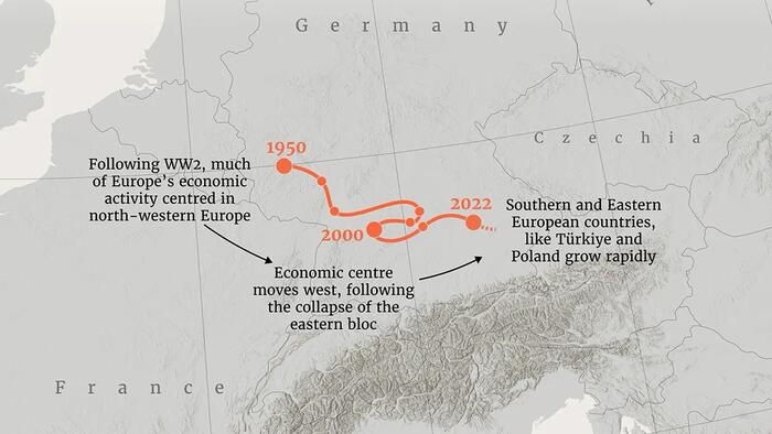
This map traces the continent’s GDP-weighted “center of gravity” from 1950 to 2022, showing how Europe’s economic core has shifted from near Cologne toward Munich over time.
The visualization,via Visual Capitalist,created byThe European Correspondentusing data from theMaddison Project Database, reveals how decades of growth in Central and Eastern Europe have gradually reshaped the continent’s economic geography.
The economic center of gravity is a geographic point calculated by averaging countries’ locations weighted by their GDP. In simple terms, it marks the location where Europe’s economic activity would balance if GDP were distributed like weight on a map.
As economies grow or shrink relative to each other, the center moves accordingly. When western economies dominate, the center shifts west; when eastern or southern regions grow faster, the point moves in their direction.
This method provides a simple but powerful way to visualize long-term changes in regional economic influence.
In the decades following World War II, Europe’s economic core sat firmly in the northwest. Industrial powerhouses like Germany, France, the UK, and the Benelux countries drove most of the continent’s output.
This concentration kept the center of gravity near Cologne in the mid-20th century. Western Europe’s rapid reconstruction and integration—through institutions like the European Economic Community—reinforced this geographic economic core.
Germanyin particular has long played an outsized role in Europe’s economy. In fact, the country’s output rivals that ofdozens of its neighbors combined.
Since the end of the Cold War, the center has gradually shifted eastward.
Source: ZeroHedge News