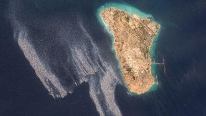
An apparent large oil spill spanning dozens of square miles of sea has been spotted off of Iran's main oil hub of Kharg Island, according to open source satellite imagery and reporting in both the NY Times and Reuters on Friday.
The reports cite images from Copernicus's Sentinel-1, Sentinel-2, and Sentinel-3 satellites taken from monitoring May 6 through 8 whichshow a huge grey-and-white slick extending out to the west of Kharg Island.
"The slick appears visually consistent with oil," said Leon Moreland, a researcher at the Conflict and Environment Observatory, toReuters. He believes it to be covering an area ofapproximately 45 square km (or nearly 18 sq miles).
While it's unclear what may have caused it, or the extent of possible damage to Kharg Island infrastructure or possibly docked tankers, the island has beenattacked by US aerial forces in the recent post.
One regional source provides the followingcommentary:
It could be the result of a leak. Other claims have suggested oil was pumped into the sea because storage space had run out due to the blockade. In newer images, the oil slick appeared to be moving south.
Social media users expressed concern over what appeared to be an oil spill in the satellite images.
“This must be dealt with quickly before the oil reaches the coasts of other Gulf states,” a Saudi influencer wrote on X, where he has more than 750,000 followers.
And separately a regional monitor and expert explains thefollowing:
Synthetic aperture radar imagery shows a large surface slick emanating from the waters around Kharg Island, Iran's primary crude oil export terminal responsible for roughly 90% of the country's oil exports.
Source: ZeroHedge News